• Other vizzes

    Are Best Practices always best?

    I recently published a viz in which I looked at some characteristics of world leaders in the last 70 years. I looked at four categories that each had two groups – Gender (Male/Female), Age Group (above/below 60), whether the leader was elected or not, and whether the country was a democracy or not. Here’s the viz I created:

    Here’s a question I feel is worth discussing:

    Should I have followed best practices for this viz?

    Let’s start by looking at some of the things I like about the viz as it is:

    • It piques my interest because it’s a little bit different than most vizzes I see.
    • I personally find it visually pleasing. I think it’s because I like the symmetry of the squares.
    • I think it manages to drive the basic message: I can tell how the ratios have changed over time.

    But what are some of the draw-backs I can identify?

    • We as humans are super bad at estimating areas. It’s the same problem I mentioned for my Child Marriage MakeoverMonday.
    • The numbers for each pair of squares always add up to 100%. That fact, however, is not obvious at first glance in this viz.
    • A simpler way to represent this data – and the one I would consider the best practice approach – would have been with a stacked bar chart. This would also make it easier to quickly see the change over time.

    So… taking the more experimental road with the dual squares or sticking to best practice and using a stacked bar chart? What’s the better approach in this case? I’m happy with the dual square chart in this context but in a business context, I would probably stick to the stacked bars. But I created a comparison below and you can judge for yourself which one you like better…

  • #MakeoverMonday

    #MakeoverMonday Week 43 – Apparel exports

    Week 43 of #MakeoverMonday gave us a dataset about the consequences of the COVID pandemic on US apparel suppliers. 

    I tried timeboxing again and limited myself to an hour. Here’s my result:

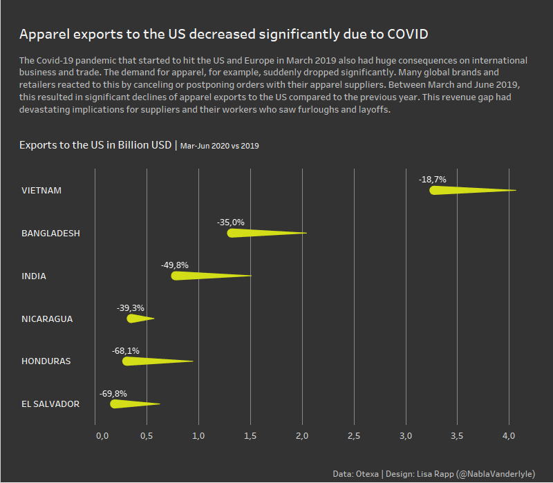
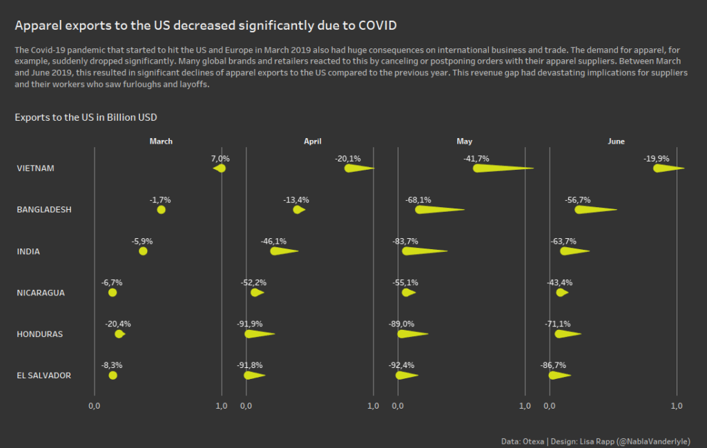
    I myself are honestly suprised by this result: First time I’ve ever used a Comet chart and I rarely do dark backgrounds. I think the comet chart works well in this case where we want to compare values for two years.

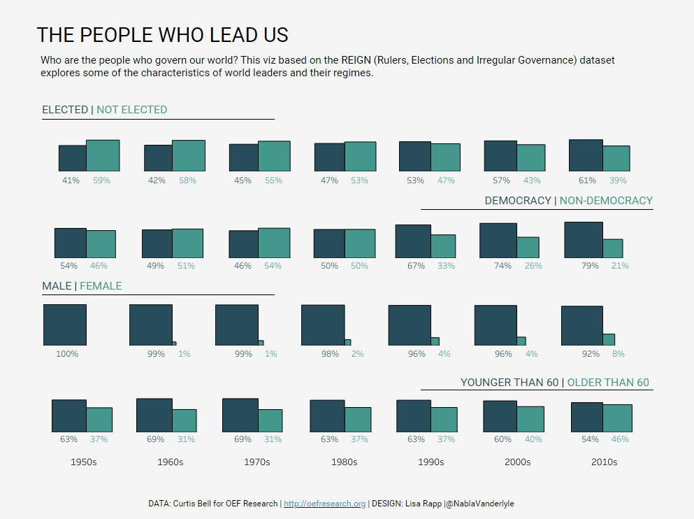
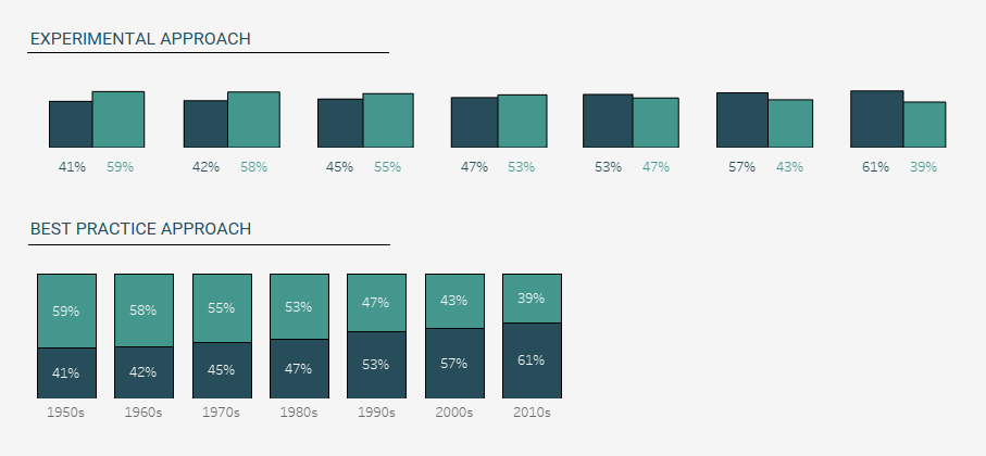
    But, in one respect, this viz is kind of a cop-out. I really struggeled with orientation – which field should I put on which axis? Usually, I follow two rules rather dilligently:

    • Time goes left to right – so on a horizontal axis
    • Categories go top to bottom – so vertical axis

    In this viz, I really struggeled finding a compromise because we had two different time dimensions (years and months) and for some reason I couldn’t find a combination I liked. So due to my time-constraint I coped out in the end and simply aggregated the months to avoid the problem.

    In hindsight, I should have included the months and could have ended up with something like this:

  • #MakeoverMonday

    #MakeoverMonday Week 41 – Data Survey Results

    Charlie gave us a pretty simple and straight-forward dataset for this week’s MakeoverMonday. It comes from DataIQ’s survey on Data Assets and Data Cultures. Basically, it’s about how many respondents of their survey came from which industry sector. 

    Here’s the simple bar chart I created with that dataset:

    Here are some of the thoughts I had while creating this:

    • I struggled to find any interesting insight in this data. I thought about grouping the sectors to find something more interesting – but I couldn’t really find a way of grouping that made sense to me. But without further grouping, the percentages become really small. You now end up with information such as ‚2% of recipients work in logistics‘ – which just doesn’t feel all that useful to me. However, the ‚Other‘ gorup was already pretty large with 11% – so putting some of the smaller percentages into that category wasn’t a viable option for me either. In the end, I just accepted the data as it is. Maybe I’m just not the right person to look at that data. Maybe it’s quite insightful for someone who works with surveys more often. I decided to not focus too much on the content and concentrate a bit more on the design aspect of it.
    • A bar chart might seem a bit boring. But I think in this case it really is the best way to present the data. But I’d be happy to be proven wrong if someone comes up with something amazing. All the other vizzes I’ve seen so far have also been bar charts, though.
    • I used a vibrant blue color (#11139a) that I had in my color inspirations for a while and finally got a chance to use.
    • I tried something I haven’t done before with the positioning of the labels on top of the bars. I did it by creating the bars and the labels on separate worksheets and then floating them on top of each other on the dashboard. There might be a better way to do this which I might explore if I ever have time. I would also try to find a way to increase the spacing between the individual bars to give them a bit more breathing room.
    • At first, I put the explainer text below the title (above the bar chart). But then I realized that there is so much whitespace in the bar chart that I’m wasting. So I placed the text there instead. I included the lines to still create a connection between the title and the text. My hope is that this guides reades to start with the title and then go to the text before actually looking at the chart. 
  • #MakeoverMonday

    #MakeoverMonday Week 40 -US GDP by State

    It’s TC20 week! What an exciting time for the datafam. This is my first Tableau Conference since I’ve become more active in the community. I was supposed to go to TC Europe in London earlier this year but… the pandemic. So now TC20 is gonna have to be virtual again. But the cool thing about that is how many people from all over the world will be able to participate. I hope I’ll see you there!

    But let’s get to the topic this post is actually about: This week’s MakeoverMonday!
    Since it is TC20 week, there was also a special Live MakeoverMonday. I managed to join the Monday evening session on Youtube
    So what was different this week? Well, the idea is the same. But the topic was introduced on the livestream and we then had an hour to work with the dataset and submit our viz. After that, the MakeoverMonday team took some time to review some of the results on the livestream. So the big difference for me this week was timeboxing

    I usually don’t limit the time I work on my MakeoverMonday viz. And it often takes me quite a while. Typically it’s not because I lack the technical skills (though that happens too, of course). I typically have a hard time settling on an idea and tend to overthink things. But getting things done quickly is an important skill. So this was an interesting and exciting exercise for me!

    So here’s what I ended up with after an hour:

    I’m actually quite surprised how much I like the result. It’s simple, you can easily compare different states and you can see some interesting patterns (check out Michigan’s 2008 dip, for example).

    How did I end up with that viz?
    I’ll let you in on a secret – it was a panicked last-ditch effort in the last 20 minutes or so. And isn’t that how it works quite often? How often do you start working with a dataset, build a viz, only to scratch it and try something else? I guess some people are well-organized, sketch out their vizzes in advance and actually stick to their plan. Well, I’m not one of those people. But in the end, you only see my finished viz and you don’t get to see all of my failed attempts. This week I’m going to change that and show you what happened before I settled on the final viz.

    A map showing the GDP of counties in the US.

    My first attempt was a simple map. I’ve never done a county-level map, so this seemed like a good dataset to try. However, the few very big values make the map pretty useless. And then you also have the usual problem of choropleth maps: Regions with small areas completely vanish. Do you see New York in that map? Me neither….

    My second attempt was a slope chart. I was hung up on that idea for quite some time. But as you can see it doesn’t work very well. There are way too many similar lines that overlap into a big mess and I don’t feel like you can gain any real insights from that chart.

  • Other vizzes

    US National Parks – an #IronQuest viz

    A data viz about US National Parks.
    My submission to #IronQuest: A mobile guide to US National Parks

    THE THEME

    This viz was created for the September round of Iron Quest which focused on Mobile-First Dashboards. I was very excited about this theme. Designing specifically for mobile was something I’ve had on my to-do list for a while. So this was a great opportunity to finally tackle this.

    THE TOPIC

    Since the theme was entirely focused on the design, it didn’t really set any limits on the topic of the viz itself. But I quickly settled on US National Parks as the topic for my viz. Since we can’t really travel because of the pandemic right now, I’ve started to do some research on potential travel plans for the future. And US National Parks are high on my post-pandemic travel bucket list. But I usually try to avoid the crowds. So I was especially interested to find out what the peak season for different parks are.

    THE DATA

    • The National Park Service provides some detailed reports on visitor stats.
    • I also used the National Park Service’s website to learn about the geology and landscapes in the parks.
    • I pulled the park descriptions and basic information from Wikipedia.
    • Wikipedia also had a list of mountains/elevations.
    • I found a data set about biodiversity in the National Parks on Kaggle.
    • Finally, I found more information about popular activities on us-parks.com.

    My data prep involved a lot of copying and pasting, and typing values into an Excel sheet manually. Not very sophisticated, but it did its job in the end.

    THE DESIGN

    For this viz, I actually started with the background. I’ve always wanted to try a gradient background. I scoured Pinterest for inspiration and found this greenish-blue gradient – which I felt would work well for the topic. I created the background in Powerpoint. I also used Powerpoint to create all the buttons. and the tree logo.

    I kept the visualizations themselves pretty simple. I stuck to pretty basic graph types overall and a monochrome black color scheme.  I used viz types like the stacked dots to get invididual marks for each National Park. This way, I was able to link them to the details page by a go-to action.

    Last point of order was including all the buttons and configuring the navigation. This actually took ages! Oh how I wish Tableau had a copy and paste function for stuff like that.

    THE VERDICT

    This #IronQuest challenge was super fun! It really motivated me to pay more attention to mobile design in the future. It’s definitely challenging – configuring all the navigation needed to make it work was quite time-consuming. On the other hand, it really forces you to keep a tight focus and to sharpen your message – which is a good exercise for any kind of dashboard!

  • #MakeoverMonday

    #MakeoverMonday Week 39 – Child Marriage

    THE PROCESS

    This week’s dataset consisted of only 4 fields: the country name, percentage of girls married by 15, percentage of girls married by 18 and percentage of boys married by 18. I decided to concentrate on the girls and not use the boys percentage. The next thing I noticed was that the girls married by 15 are a subset of the girls married by 18 and I wanted my viz to reflect that somehow. That’s how the idea of the squares within squares formed in my head.

    But how to get there?
    I knew I had to use polygons – something I’ve never really worked with before. Luckily, the Flerlage Twins are there to help you out with a handy blog post. Some data prep was needed (pivot the measure columns and quadruple the data to be able to draw the 4 corners of the square), do some calculations to get the positions of the corners – and voilà!

    Next, I had to get the country labels look nice. For that, I used another trick that was in Kevin’s blog post mentioned above: create the labels on a separate sheet and float them behind the polygon viz. I positioned the labels using transparent shapes – another trick I learned from the Flerlage’s blog. This has quickly become one of my favorite and most-used little tricks ever since I read the 14 use cases for transparent shapes blog post. 

    All that was left after that was implementing the sort functionality. I actually handled this in data prep by creating index fields based on the three sort options. Depending on the sorting parameter I would then use those indexes to calculate the X and Y position of each country in the small multiples grid. I then created the sort buttons and configured the parameter action.

    THE VERDICT

    All in all, I really liked how this turned out. It was really fun to try something new and explore polygons. I also rarely do small multiples, so that was a good opportunity for me to get more used to them. What’s also cool is that this was one of those cases where I had an idea in my head and I actually managed to recreate that exact idea – something that sadly doesn’t happen all the time. I do feel like this viz got more attention than I would usually get – so I guess other people out there liked it, too.

    However, let’s be very clear about something: This is not necessarily what I would call a best practice approach. Is it compelling to look at? I would say so. But is it the best way to communicate the data? Maybe not. Because check out the example on the right: If the white square is 100% – how much do you think the grey square represents? The correct answer is 76%! The first time I saw this I thought my calculations must be wrong. But I double-checked. They’re not. It’s just that we are super bad at estimating and comparing areas!